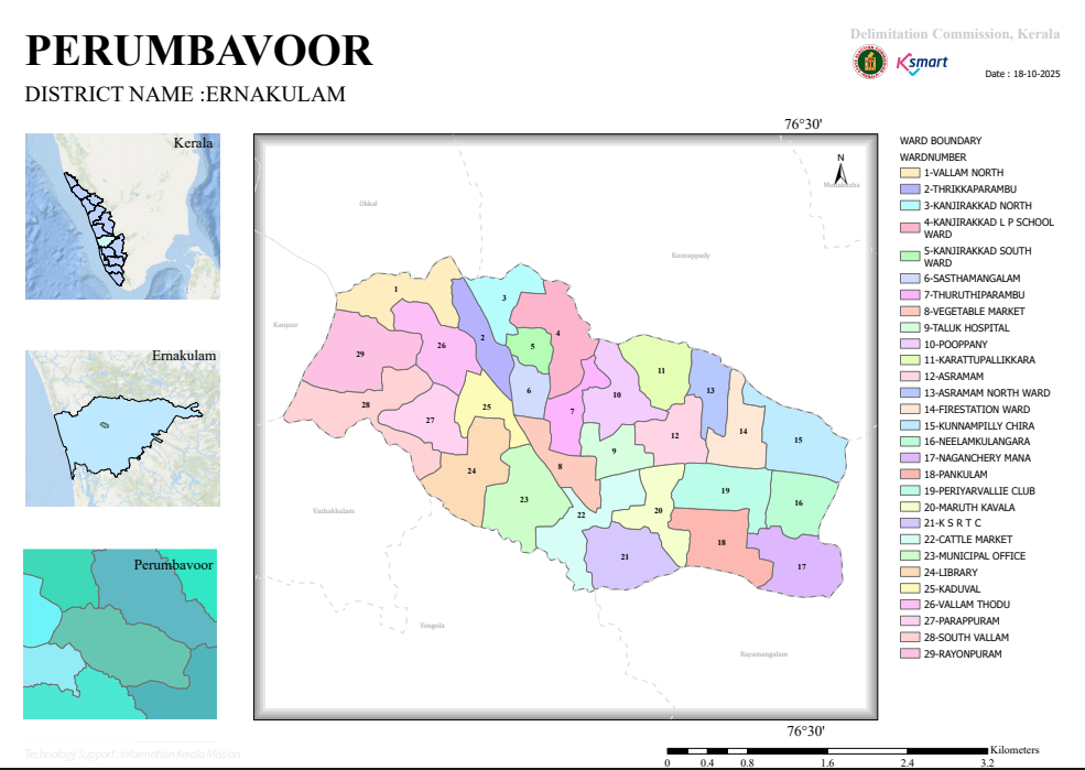
1. 📍 General Information
- District: Ernakulam
- Local Body: Perumbavoor Municipality
- Prepared by: Delimitation Commission, Kerala
- Date of Map: 18-10-2025
- Map Type: Administrative Ward Boundary Map
👉 This is an official delimitation map used for governance, elections, and planning.
2. 🗺️ Administrative Structure
- Total Wards: 29
- Each ward represents a local electoral and administrative unit.
- Ward boundaries are clearly demarcated for:
- Governance
- Resource allocation
- Electoral representation
👉 The municipality is well-divided for decentralized administration.
3. 🧭 Geographic Location & Boundaries
The municipality is surrounded by:
- Vengola
- Koovappady
- Okkal
- Mudakuzha
- Kanjoor
- Rayamangalam
- Vazhakkulam
👉 This indicates:
- A central urban hub
- Surrounded by rural/semi-urban panchayats
4. 🏙️ Ward Classification & Naming Pattern
A. Residential / Locality-Based Wards
Examples:
- Vallam North (Ward 1)
- Rayonpuram (Ward 29)
- Parappuram (Ward 27)
👉 Represent settlement-based divisions
B. Institutional / Landmark-Based Wards
Examples:
- Taluk Hospital (Ward 9)
- Fire Station Ward (Ward 14)
- Municipal Office (Ward 23)
- Library (Ward 24)
- KSRTC (Ward 21)
👉 Indicate important service and administrative centers
C. Economic Activity Zones
Examples:
- Vegetable Market (Ward 8)
- Cattle Market (Ward 22)
👉 Show trade and commercial concentration areas
D. Subdivided Localities
Examples:
- Kanjirakkad North (Ward 3)
- Kanjirakkad South (Ward 5)
👉 Indicates population density requiring division
5. 🌊 Physical & Environmental Features
- Presence of water bodies / streams (Thodu) like Vallam Thodu
- Influence of Periyar River region (implied from locality names)
- Mixed landscape:
- Urban core
- Semi-rural outskirts
👉 Suggests:
- Possible flood-prone zones
- Dependence on natural drainage systems
6. 📊 Spatial Characteristics
- Central Area:
- Administrative & commercial (Municipal Office, Market, KSRTC)
- Peripheral Areas:
- Residential and semi-rural (Vallam, Rayonpuram)
👉 Shows a typical urban pattern:
- Dense core
- Gradual transition to less dense outskirts
7. 📏 Map Features
- Scale: 0 – 3.2 km
- Includes:
- Ward boundaries
- Ward numbers
- Surrounding regions
- Uses GIS sources (Esri, Garmin, NaturalVue)
8. 🏛️ Administrative Importance
This map is useful for:
- 🗳️ Local body elections
- 🏗️ Urban planning
- 🚰 Infrastructure development
- 🧾 Property and jurisdiction reference
9. ✔️ Key Findings
- Perumbavoor Municipality has a well-structured 29-ward system
- Naming reflects:
- Geography
- Institutions
- Economic functions
- Balanced mix of:
- Urban infrastructure
- Residential zones
- Semi-rural extensions
📌 Conclusion
The map presents Perumbavoor as a moderately urbanized municipality with:
- A centralized service and administrative core
- Decentralized ward-level governance
- Strong linkage to surrounding rural areas
👉 Overall, it reflects planned administrative division supporting efficient local governance.
Links
Images